Sprache wählen

939 Öxi

River Crossing

643 Strandavegur

River Crossing

635 Snæfjallastrandarvegur

River Crossing

630 Skálavíkurvegur

River Crossing

622 Svalvogavegur

River Crossing

558 Berserkjahraunsvegur

River Crossing

214 Kerlingardalsvegur

River Crossing

F985 Jökulvegur

River Crossing

F980 Kollumúlavegur

River Crossing

F959 Viðfjarðarvegur

River Crossing

F946 Loðmundarfjarðarvegur

River Crossing

F936 Þórdalsheiðarvegur

River Crossing

F923 Jökuldalsvegur

River Crossing

F910 East Austurleið

River Crossing

F909 Snæfellsleið

River Crossing

F905 Arnardalsleið

River Crossing

F903 Hvannalindavegur

River Crossing

F902 Kverkfjallaleið

River Crossing

F894 Öskjuvatnsvegur

River Crossing

F821 Eyjafjarðarleið

River Crossing

​F735 Þjófadalavegur

River Crossing

F586 Haukadalsskarðsvegur

River Crossing

F578 Arnarvatnsvegur

River Crossing

F337 Hlöðuvallavegur

River Crossing

F335 Hagavatnsvegur

River Crossing

F333 Haukadalsvegur

River Crossing

F261 Emstruleið

River Crossing

F233 Álftavatnskrókur

River Crossing

​F223 Eldgjárvegur

River Crossing

​F66 Kollafjarðarheiði

River Crossing

614 Rauðisandsvegur

River Crossing

F224 Landmannalaugavegur

River Crossing

F208 Fjallabaksleið Nyrðri

River Crossing

F347 Kerlingarfjällavegur

River Crossing

F-35 Kjälvegur

River Crossing

F839 Leirdalsheiðarvegur

River Crossing

F899 Flateyjardalsvegur

River Crossing

Strandavegur, designated as Road 643, is a remote and scenic route located in Iceland's Westfjords region. This unpaved road stretches approximately 98.8 kilometers (61.39 miles), running from Route 61 (Djúpavegur) all the way up to Norðurfjörður and the renowned Krossneslaug swimming pool. ​

Route Overview:

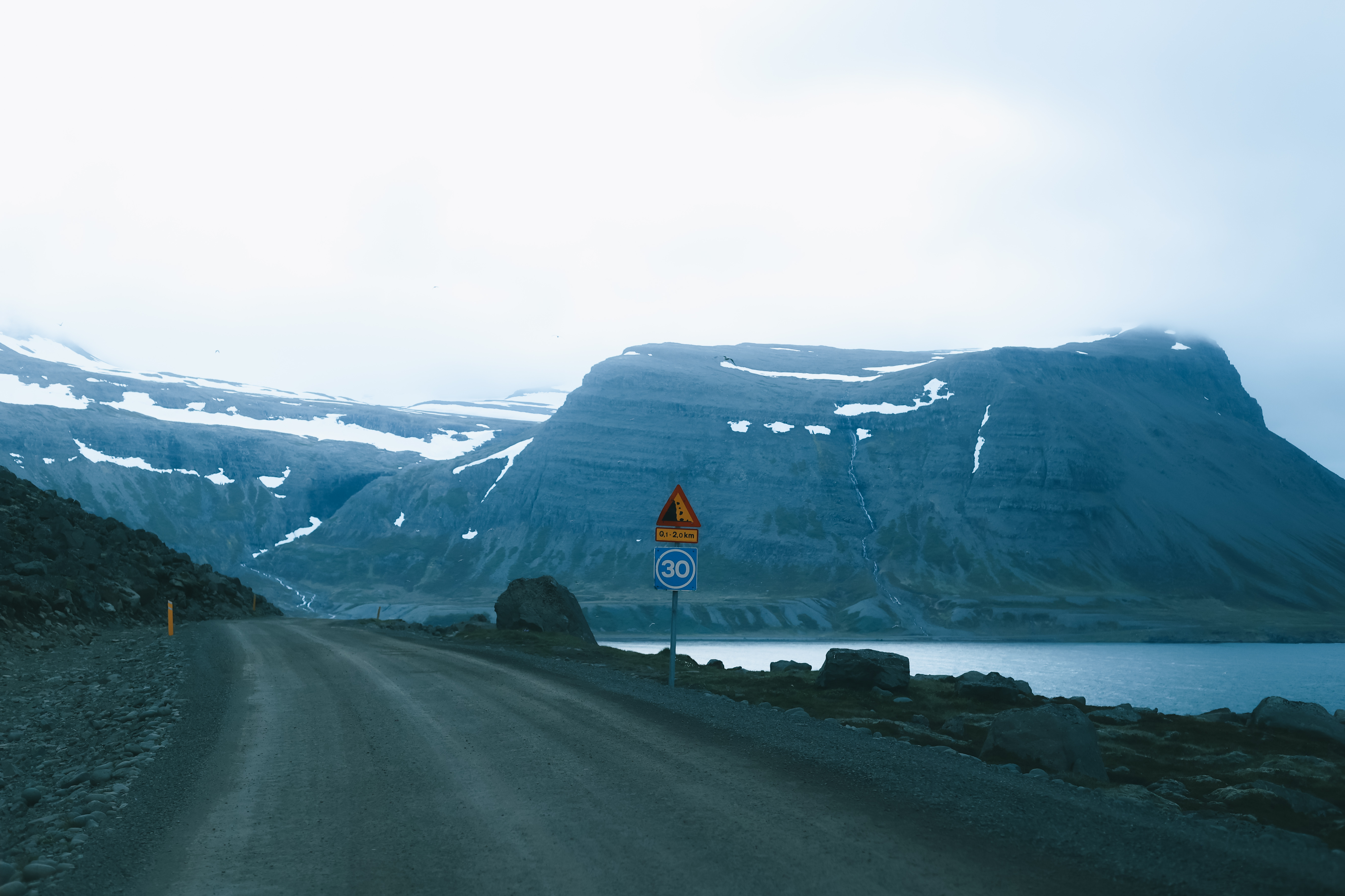
Road 643 winds along the Strandir coast, traversing one of Iceland's most isolated regions. The drive offers breathtaking coastal views, with the road snaking between steep rocky summits and the pounding sea. However, it's important to note that thick fog can occasionally obscure these views, reducing visibility. ​

643 Strandavegur | © Ervin Drives Around

643 Strandavegur

Driving Conditions and Recommendations:

  • Road Surface: The road is entirely unpaved and is characterized by potholes, narrow passages, and steep sections, some of which run along the edge of cliffs. While it's a very scenic coastal drive, it's not an easy one and may be a bit intimidating in certain parts.
  • Vehicle Requirements: During the summer months, the road is generally passable with an SUV; however, a 4x4 vehicle is recommended to navigate the challenging terrain safely. While officially accessible to 2WD vehicles, the numerous potholes and rough conditions make it more suitable for 4WD vehicles.
  • Seasonal Accessibility: The road is typically impassable from late October through May due to weather conditions. Travelers should verify current road statuses before planning their journey.

643 Strandavegur, westfjords, off road, gravel, what car, scenic drive, krossneslaug
643 Strandavegur

Notable Attractions:

  • Krossneslaug Swimming Pool: At the northern end of Road 643 lies Krossneslaug, a famous public swimming pool that offers a unique bathing experience with stunning ocean views.

Krossneslaug Swimming Pool

  • Gjögur

Gjögur
Gjögur

Campsites Along Road 643 Strandavegur:

Laugarhóll í Bjarnarfirði Campsite: This campsite offers essential amenities such as water and toilets. Adjacent to the campsite is Hotel Laugarhóll, which features a naturally warm geothermal outdoor swimming pool (32-35°C) and an adjacent hot pool (41°C), providing a relaxing experience after a day of exploration. The area is rich in activities, including hiking, bird watching, and visits to nearby attractions like the ghostly herring factory in Djúpavík and the warm swimming pool at Krossnes. The campsite is open from June 1 to September 15 (earlier if weather permits).

Laugarhóll í Bjarnarfirði Campsite

Djúpavík Campsite and Hotel: While specific details about the campsite facilities are limited, Hotel Djúpavík offers accommodations and dining options. The area is known for its historical significance, particularly the old herring factory, which adds a unique cultural touch to the stay. ​

Djúpavík Campsite and Hotel

Nordurfjördur Urðartindur Campsite: Located in Norðurfjörður, this campsite boasts spectacular views over the fjord and surrounding mountain ridges. Facilities include toilets, cooking amenities, electricity hookups for RVs, and a large room accommodating up to 80 people, equipped with tables and dishwashing areas. Additional accommodations include small cottages and rooms in a converted barn. Nearby attractions feature a sandy beach, hiking trails, and the Krossnes swimming pool situated by the beach. The campsite is particularly suitable for both small and larger groups, such as reunions and weddings. Rates for adults are 1,500 ISK, with children under 15 staying free of charge.

Nordurfjördur Urðartindur Campsite
Nordurfjördur Campsite

Valgeirsstaðir Hut and Campsite: Operated by the Iceland Touring Association, this accommodation offers a unique experience in the remote Strandir region. While specific details about the facilities are limited, the hut provides a rustic lodging option for travelers seeking to explore the untouched landscapes of Norðurfjörður.

Valgeirsstaðir Hut and Campsite

Practical Considerations:

  • Travel Time: Driving the entire length of Road 643 without stops typically takes between 2 to 3 hours. However, given the scenic nature of the route, travelers often take additional time to enjoy the views and attractions.
  • Services and Amenities: The area is quite remote, with limited services available. Travelers should ensure they have adequate supplies, including food, water, and fuel, before embarking on the journey.​

In summary, Strandavegur (Road 643) offers a unique and picturesque driving experience along Iceland's rugged coastline. With proper preparation and caution, travelers can enjoy the natural beauty and tranquility of this secluded region.

Map of F-Road